Militant death cult Daesh released an audio message from spokesperson Abu Muhammad al-Adnani on Saturday, a much-anticipated event among the group’s supporters.
So overcome with excitement where they that some photographed handwritten messages of support and published them to channels on Telegram, the encrypted messaging app where many pro-Daesh communities interact.
The only problem? Many included clues as to their location and have since been tracked down by Twitter users around the world. Eliot Higgins, founder of Bellingcat and a member of the First Draft Coalition, first saw “ISIS watchers” sharing the pictures on social media and corralled his followers into tracking down their location.
Four locations have so far been found, revealing not only the same scenery as in the pictures, but the likely position of the photographer. The locations include a private home, an apartment building and a hotel. Authorities have been alerted.
“There were more images, not that many,” Higgins said, “but the ISIS supporters were retweeting like crazy and trying to get this whole thing trending in Paris and claiming Amsterdam and London.
“They’re doing that to create this ‘scary’ atmosphere and by geolocating it we made it look ridiculous. Because there are four pictures some people are calling them Four Lions [after a 2010 satirical film about bumbling jihadists in the UK] and it takes the narrative they were trying to build of this aura of invulnerability and punctures it and makes it look like a joke.”
So how did they track down these ‘Four Lions’? The investigation boiled down to visual clues in the pictures themselves.
Germany
One of the first pictures to be geolocated was found in the German town of Münster.
ISIS fanboy geolocated by @hotzn1 & @ArtWendeley to this exact spot 51°59’35.1″N 7°38’55.4″Ehttps://t.co/vTd7mo0T6c pic.twitter.com/P2lrGZRh8G
— Eliot Higgins (@EliotHiggins) May 21, 2016
The road junction, surrounding buildings and the bus can all help, said Higgins, but the advertising pillar was the smoking gun.
“The company that runs those pillars has all the sites listed on their website,” he said. “There you can narrow down all the possible locations it could be and then from there it’s quite easy to pick up on the locations based off the other clues in the pictures.”
Once researchers had figured out the number on the bus they cross-referenced the bus route with the map of the advertising pillars to find the location.
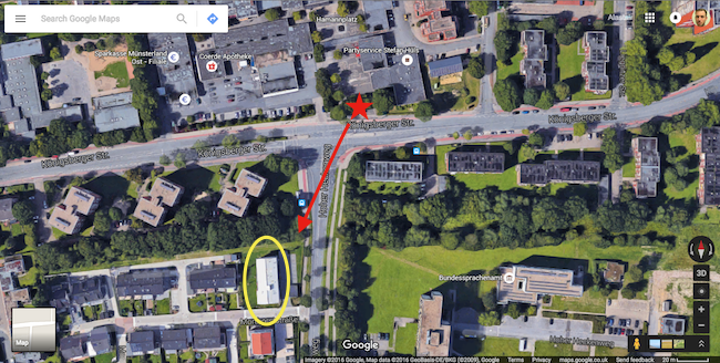
Looking at the location on Google Maps you can see the exact location the photograph was taken (red star), the direction, (red arrow) and the white building in the background of the photo. Zooming in closer reveals signs of the advertising pillar.
Paris
Here ISIS supporter in #Paris. With these proISIS msgs, group creates impression that they have worldwide network pic.twitter.com/DKZjDdeNO2
— Jenan Moussa (@jenanmoussa) May 21, 2016
“You could make out the Suzuki sign [behind the paper] and there’s only a few places like that in Paris which are the retailers,” said Higgins, crediting Twitter user @Naenil for the find. “So then it was narrowing down those locations and figuring out the rest from that”.
A quick search for “suzuki Paris” reveals the retailers, and a street level preview is provided when clicking on each. When going down to full street view on Rue Championnet, the same signs and clues are present as in the image itself.
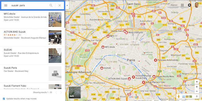
There are relatively few official Suzuki retailers in Paris
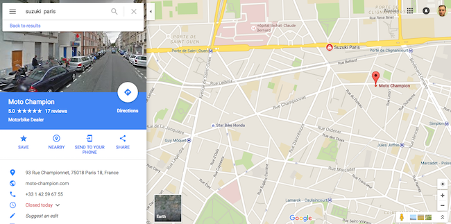
Clicking on each reveals a street-level preview
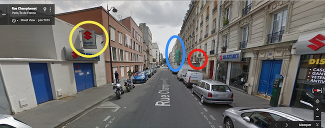
The positions of the Suzuki sign (yellow), shop sign (red) and scaffolding (blue) all match with the photo
London
ISIS Fanboy number 2 was geolocated to this spot in London h/t @mamzbondok https://t.co/NFsuoM8nhJ pic.twitter.com/7OSC5gfE1t
— Eliot Higgins (@EliotHiggins) May 21, 2016
The picture from London includes a bus stop and shop fronts, but the biggest clue came from the bridge in the distance, said Higgins.
“That was just a local recognising the station it was at,” he said. “Although it was quite far in the distance,it’s quite a distinct piece of signage and I think they figured that out by crowdsourcing what people see in their real life.”
Although partially obscured by the bus, the lettering on the bridge reads ‘Bruce Grove’ – a train station in north London – as spotted by @mamzbondok.
When looking at the area on street view other elements match the photograph, including the bus stop with the letter ‘K’, the green street sign and distinctive red semi-circle which makes up part of the sign for a church.
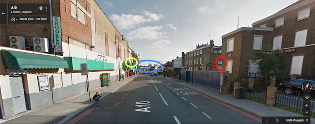
The bus stop (red), bridge (blue), street sign (green) and church facade (yellow) all match the picture
Holland
Let’s see if the Twitter open source investigation hivemind can locate this one @hotzn1 @ArtWendeley @trbrtc pic.twitter.com/N2nFZgWNp4
— Eliot Higgins (@EliotHiggins) May 21, 2016
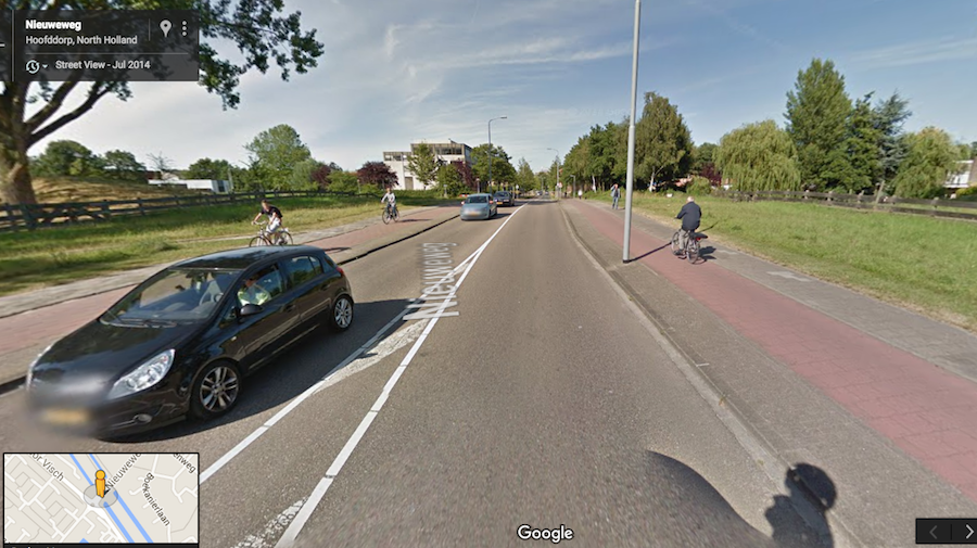
The picture from Holland proved more difficult, said Higgins, because the photographer was “lying” about his location.
Investigators initially scoured locations in Amsterdam, as the picture suggests, but the location was eventually tracked down to Hoofddorp, a town near Amsterdam’s Schiphol Airport.
ISIS Fanboy number 4 geolocated in Holland, thanks to the many of you that helped https://t.co/ZjUBXaSxIR pic.twitter.com/XW5i0p7cjA
— Eliot Higgins (@EliotHiggins) May 21, 2016
“The main thing is looking at what’s in the picture and what is a design system,” he said. “Then, do we have information about that system?
“It reminds me of Syria where although a video was filmed entirely in desert there were huge power pylons in the distance. We found a map that has the network of all the power pylons in Syria, with a few running through deserts.
“So based off seeing that structure, realising it was part of an organised system, and then getting access to the map and the details of that system, you can start narrowing down the potential areas to look in quite quickly.”
The collaborative nature of the investigation was the most useful in being able to track down the locations, said Higgins, as his followers and other Twitter users worked together to share information.
“I’m sure these images could have been done by one person but why bother doing that when, like me, I can call on 42,000 Twitter followers to do it while I’m doing the ironing,” he said. “It’s making use of all the resources that you have available to you and sometimes that’s the people you’ve got following you.”
Want to know more about geolocation? Check out ‘Piecing together clues for verification‘ about the types of visual slues in pictures and videos, the First Draft Observation Challenge for picking out clues from images and our Geolocation Challenge for getting to grips with Google Maps for finding locations.


